|
|
 |
 |
|
|
|
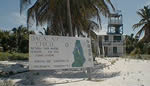 The park opened officially August 23, 1996. It comprises a 15,000-acre
marine reserve and 12,000 acres of terrestrial reserve. The park opened officially August 23, 1996. It comprises a 15,000-acre
marine reserve and 12,000 acres of terrestrial reserve.
The objectives of the Bacalar Chico Marine Reserve are: to ensure the
health of the fishery stock, regulate water sports, conduct monitoring
and assist in research. Provide job opportunities to tour guides and
a venue for recreational activities, prohibit illegal fishing and to
deter other illegal activities which may be detrimental to the health
of the flora and fauna.
 The reserve is situated just south of Xcalak on the northern
tip of Ambergris Caye. The reserve is on Belizean territory. At present
the park is accessible only by sea from the Xcalak, only about 25 minutes
away
by
boat. And
from points on Ambergris Caye, from Sarteneja and elsewhere on the
mainland off
the Bay of Chetumal (several hours by boat). The reserve is situated just south of Xcalak on the northern
tip of Ambergris Caye. The reserve is on Belizean territory. At present
the park is accessible only by sea from the Xcalak, only about 25 minutes
away
by
boat. And
from points on Ambergris Caye, from Sarteneja and elsewhere on the
mainland off
the Bay of Chetumal (several hours by boat).
Bacalar Chico Rangers are presently working on establishing an eco-tour
of the reserve in order to generate funds to help with the upkeep of
the reserve, to provide business opportunities for tour guides.
In the reserve the green sea turtle
and the loggerhead have nesting sites between Robles and Rocky Point;
the offshore marine habitat once known as a breeding area for Queen
conch;
and the seasonal spawning bank for the nassau and yellowfin groupers;
the high diversity of terrestrial and vegetation zones.
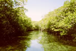
The region encompasses intra-island lagoons, mud flats, sink holes,
mangroves forests, savannahs, semi deciduous forest and is home to
many different animals.
There are about eight different Mayan sites in the
Bacalar Chico area two of which, San Juan and Chac-balam have been
partially excavated and have been made somewhat accessible by trails.
|
|
|
|
|
TOP |
|


