|
|
 |
Topology - Demography
- Geology
- Climate
- Flora
and Fauna |
|
|
|
|
| |
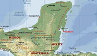 Quintana Roo is one of three states of the Yucatan peninsula. The
Caribbean coast completely lies in this state. The northern part
of the coast is called Riviera Maya, the southern part of the coast
is called Costa Maya. Xcalak is a small fisherman village on the
Costa Maya. Quintana Roo is one of three states of the Yucatan peninsula. The
Caribbean coast completely lies in this state. The northern part
of the coast is called Riviera Maya, the southern part of the coast
is called Costa Maya. Xcalak is a small fisherman village on the
Costa Maya. |
| |
| |
 |
District |
District capital |
 |
|
| Cozumel |
Cozumel |
| Felipe Carrillo Puerto |
Felipe Carrillo Puerto |
| Isla Mujeres |
Isla Mujeres |
| Othón P. Blanco |
Chetumal |
| Benito Juárez |
Cancún |
| José María Morelos |
José María Morelos |
| Lázaro Cárdenas |
Kantunilkín |
| Solidaridad |
Playa del Carmen |
| |
|
| |
|
|
| |
The distance from Xcalak / Mahahual (Majahual) to the following cities is:
Mahahual (Majahual) 55 Km
Limones 115 Km
Bacalar 163 Km
Chetumal 193 Km
Felipe Carrillo Puerto 186 Km
Tulum 180 Km
Playa Del Carmen 343 Km
Puerto Morelos 370 Km
Cancun 407 Kmd
Merida 436 Km
|
| |
|
| |
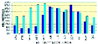
At
this moment there are about 1.2 million inhabitants in Quintana
Roo. In 1970 there were only 90.000 inhabitants in Quintana
Roo. The current annual growth of the population is 6 % (in
Mexico the overall growth is 2 %).
The high growth of the population is mainly due to the increase in tourism
in the north of Quintana Roo (Cancan, Playa Del Carmen). The tourist industry
and it's support industry causes inhabitants of other states to migrate to
Quintana Roo. Quintana Roo has the highest migration of all Mexican states,
followed by Baja California and Mexico D.F.
In the chart you can see the results of the large influx of young and middle
aged people in Quintana Roo for the demographic pyramid of the state. |
| |
|
| |
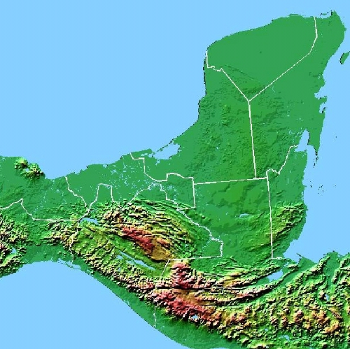
 Quintana
Roo is a fairly low state in terms of elevation. The elevation
lies between 0 and 275 meters above sea level. Along the Caribbean
coast the elevation is approx. 1 to 5 meters. Quintana
Roo is a fairly low state in terms of elevation. The elevation
lies between 0 and 275 meters above sea level. Along the Caribbean
coast the elevation is approx. 1 to 5 meters.
The ground is made up of lime stone covered with a thin layer of sand. The
layer of sand is so thin that it lacks the ability to store water and form
a buffer for the rain fall. This causes the rain to run through the top layer
of sand and penetrate the soft lime stone quickly. Over the past hundred thousands
of years this has caused erosion of the lime stone. Large underground rivers
and lakes were formed. In some cases the roof of these underground lakes collapsed
and a well or Cenote was formed.
|
| |
|
|
| |
|
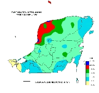
During the fall , tropical storms, called hurricanes, often blow into the area,
and during the winter and spring there is a constant battle between the hot
and dry counter trade winds and polar air masses called nortes (north winds).
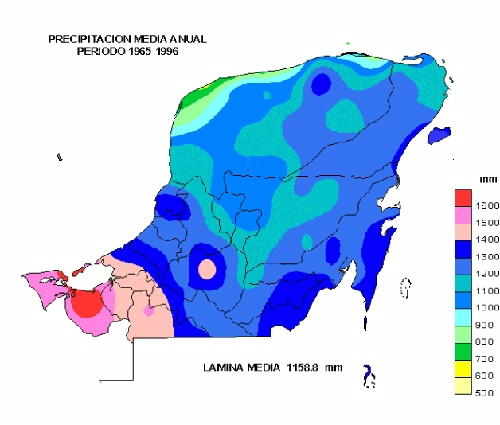
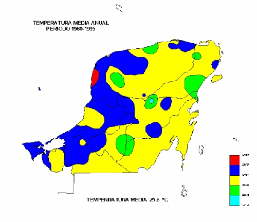
The average rainfall is approx. 1160 mm. There are large differences between
area's in Quintana Roo. The average minimum is approx. 450 mm, The average
highest is approx. 1660 mm. The average yearly rain fall distribution per area
and average monthly rain fall is shown in the maps below. Dry season is from
approx. January to June.
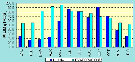
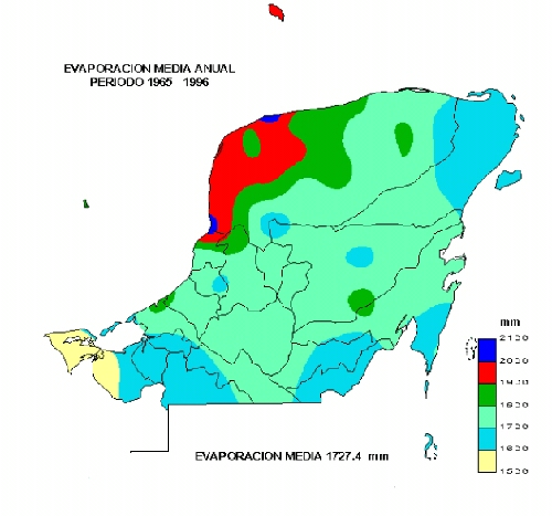
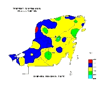
The average evaporation is approx. 1720 mm. There are large differences between
area's in Quintana Roo. The average yearly evaporation per area is shown in
the map below.
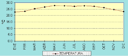
The difference between winter and summer temperature is relatively small, about
5 degrees C. The maximum is around 28 degrees C and the minimum is around 23
degrees C. The average yearly temperature per area and average monthly temperature
is shown in the maps below.
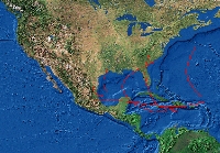
The Caribbean is well known for it's storms called hurricanes. Most hurricanes
will start in the east part of the Caribbean and turn towards Florida, USA.
The most likely route to follow is depicted below:
There are 5 categories of hurricanes:
| Category |
Wind force [km/h] |
Central Pressure [millibar] |
|
| I |
119 to 153 |
984 to 980 |
|
| II |
154 to 177 |
979 to 960 |
|
| III |
178 to 209 |
974 to 940 |
|
| IV |
210 to 249 |
939 to 920 |
|
| V |
over 249 |
lower than 920 |
(Waves over 5.4 m) |
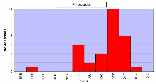
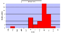
From 1886 until 1996 there have been 85 hurricanes in Quintana
Roo. This averages on 1.29 years between each hurricane. The chart
below shows that the hurricanes are most likely to occur in September
or October:
 |
| |
|
|
| |
The flora and fauna on the Costa Maya is abundant.

To protect these precious area's there are several national parks:
- Sian Ka'an Biosphere Reserve
- Banco Chinchorro Marine and Archeological Reserve
- Parque Nacional Arrecifes de Xcalak
|
| |
| |
|
|
|
TOP |
|